Townland record details , townlands are the smallest official land division but many contain locally used placenames .
Explanation of administrative divisions such as D.E.D.s , Civil Parishs and Baronies , also some information on land measurement …
Garraun |
Official Townland name |
| Civil Parish | Moorgagagh |
| Barony | Kilmaine |
| Poor Law Union | Ballinrobe |
| County | Mayo |
| Registrars District | Cong |
| D.E.D. | Dalgan |
| Area | 82 A. 3 R. 5 P. |
| O.S. 6″ sheet(s) | Mayo 121 . 122 |
| Griffiths Valuation | Poor Law Union of Ballinrobe – Page # 137 |
Griffiths Valuation details :: 1848-54
Click on the Griffiths Valuation Page # 137 to see a list of tenants with plot numbers to match the Griffith map.
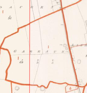 |
Townland plot mapGriffith’s final published valuation of South Mayo is dated circa 1854 due to the fact that Lady De Clifford is listed as owner of Dalgan and Patrick Kirwan owned it until sold in 1853 on account of the Encumbered Estates Act.The original surveys of Shrule were carried out in late 1838 ( from surveyors letters ). Click on the map on the left to see a larger version |
| Tenants Name in the valuation | Landlords name | Comments |
| Patrick Blake | Isadore Blake | N |
Tithe Applotments :: 1828 – 38
| Tenants Name in the records | Placename as recorded | Notes |
| Pat Kine | Gurrane |
Placenames
Placenames mentioned in this townland are :
Field Name Book
Field Name Book description from 1838/1839 noted by the surveyors who produced the O.S maps originally.
Gurrawn
B.S.S.M. : 5
Garrán, a copse. : Beal atha na nGarran, mouth of the ford of the copses.
- Gauraun : J. 0’D,
- Garrane : County Book,
- Garran : Strafford’s Survey
- Garran : Inq. temp. Eliz.
- Garran : Inq. temp. Jac. I.
- Garran : Inq. temp. Car. I.
This td. is situated in the north side of the parish.
It is bounded on the N. by the ph. of Kilmainebeg; E. by the td. of Lisheenielegaun; and S.and W by the td. of Cregnanagh.
It contains 82a. 3r. 5p., and is the property of Mr. Blake, of Towerhill. Agent, Anthony Blake, of Galway.
It is all let to one man, who is a Roman Catholic, on a lease of 3 lives or 31 years, at a yearly rent of 24s. per acre.
The soil is light, with limestone; it provides bad grazing, and middling props of wheat, oats and potatoes.
There is one ancient fort in the east side of this td.
The shrule.com placename database covers the Poor Law Unions of Ballinrobe and Tuam roughly a 15 kilometer radius centered on Shrule , the townland database covers most of Connaught in lesser detail .
When searching for a placename type some or all of the word and click search. If you are unsure of the spelling try a part of the word . For example the placename Mocharra sounds like Moharra so if you search for arra you should find it. For example a placename record ( eg Rostaff ) gives the townland ( eg Moyne ) and the civil parish ( eg Shrule ) .
Civil Parish details available :: 40
Abbeyknockmoy , Annaghdown , Athenry , Belclare , Ballinchalla , Ballinrobe , Cargin , Clonbern , Claregalway , Cong (Galway) , Cummer , Dunmore , Donaghpatrick , Kilbennon , Kilconla , Kilmoylan , Kilcoona , Killeany , Killursa , Kilkilvery , Killower , Lackagh , Moylough , Monivea , Killererin , Tuam , Ballinchalla , Ballyovey , Ballinrobe , Ballintober , Cong , Kilcommon , Kilmolara , Kilmainebeg , Kilmainemore , Moorgagagh , Mayo , Robeen , Shrule , Unknown , more to come . . . .Barony details available
Clare , Kilmaine , more to come . . . .Poor Law Unions details available
Tuam , Ballinrobe , more to come . . . .Land divisions and Administration
Go to the Map Resources page for descriptions and explanations of the land divisions used in genealogy plus explanations of terms etc…
Civil Parish Maps
There are two general index maps of the Civil Parishes , one for South Mayo and the other for North Galway . These correspond roughly to the Baronies of Kilmaine (Co Mayo ) and Clare (Co Galway) and show the civil parish boundaries and parish locations in relation to each other.
Townland Index maps .
Official O.S. townland names in Shrule parish
Unknown , Ballisnahyny , Ballycurrin Demesne , Ballynalty , Brackloon , Brodullagh North , Brodullagh South , Bunnafollistran , Cahernabrock , Cloghmoyne , Cloonbanaun , Commons , Cullagh , Dalgan Demesne , Glasvally , Gortatober , Gortbrack , Kinlough , Mocollagan , Mocorha , Mounthenry , Moyne , Ramolin , Rooaunalaghta , Shrule , Shrule Town , Toorard , Cornehan , if the place you seek is not here it’s not an official townland name , search or select the parish link to see all placenames in that parish.
There are townland index maps for Shrule and the surrounding civil parishes available below . They show the townland boundaries and main features of the Civil Parish . They can be useful in locating adjacent townlands or parishes to the one you may be researching.
Categories: .
Content supplied from many sources. eMail me if errors are found.