Townland record details , townlands are the smallest official land division but many contain locally used placenames .
Explanation of administrative divisions such as D.E.D.s , Civil Parishs and Baronies , also some information on land measurement …
Brodullagh North |
Official Townland name |
| Civil Parish | Shrule |
| Barony | Kilmaine |
| Poor Law Union | Ballinrobe |
| County | Mayo |
| Registrars District | Cong |
| D.E.D. | Shrule |
| Area | 249 A. 2 R. 32 P. |
| O.S. 6″ sheet(s) | Mayo 121 122 123 |
| Griffiths Valuation | Poor Law Union of Ballinrobe – Page # 155 |
Census of Ireland 1901 Head of Household (B1).
| Head of Household’s :: Name | Land Holder (Landlord) | Building type |
| Mary Biggins | Mary Biggins | Private dwelling with 2 rooms. |
| Michael Moghan | Michael Moghan | Private dwelling with 2 rooms. |
| Walter Monaghan | Walter Monaghan | Private dwelling with 2 rooms. |
| Michael Moghan | Michael Moghan | Private dwelling with 2 rooms. |
| Mary Duddy | Mary Duddy | Private dwelling with 2 rooms. |
| Mary Walsh | Mary Walsh | Private dwelling with 2 rooms. |
| Mary Madden | Mary Madden | Private dwelling with 2 rooms. |
| Mary Hession | Mary Hession | Private dwelling with 2 rooms. |
Griffiths Valuation details :: 1848-54
Click on the Griffiths Valuation Page # 155 to see a list of tenants with plot numbers to match the Griffith map.
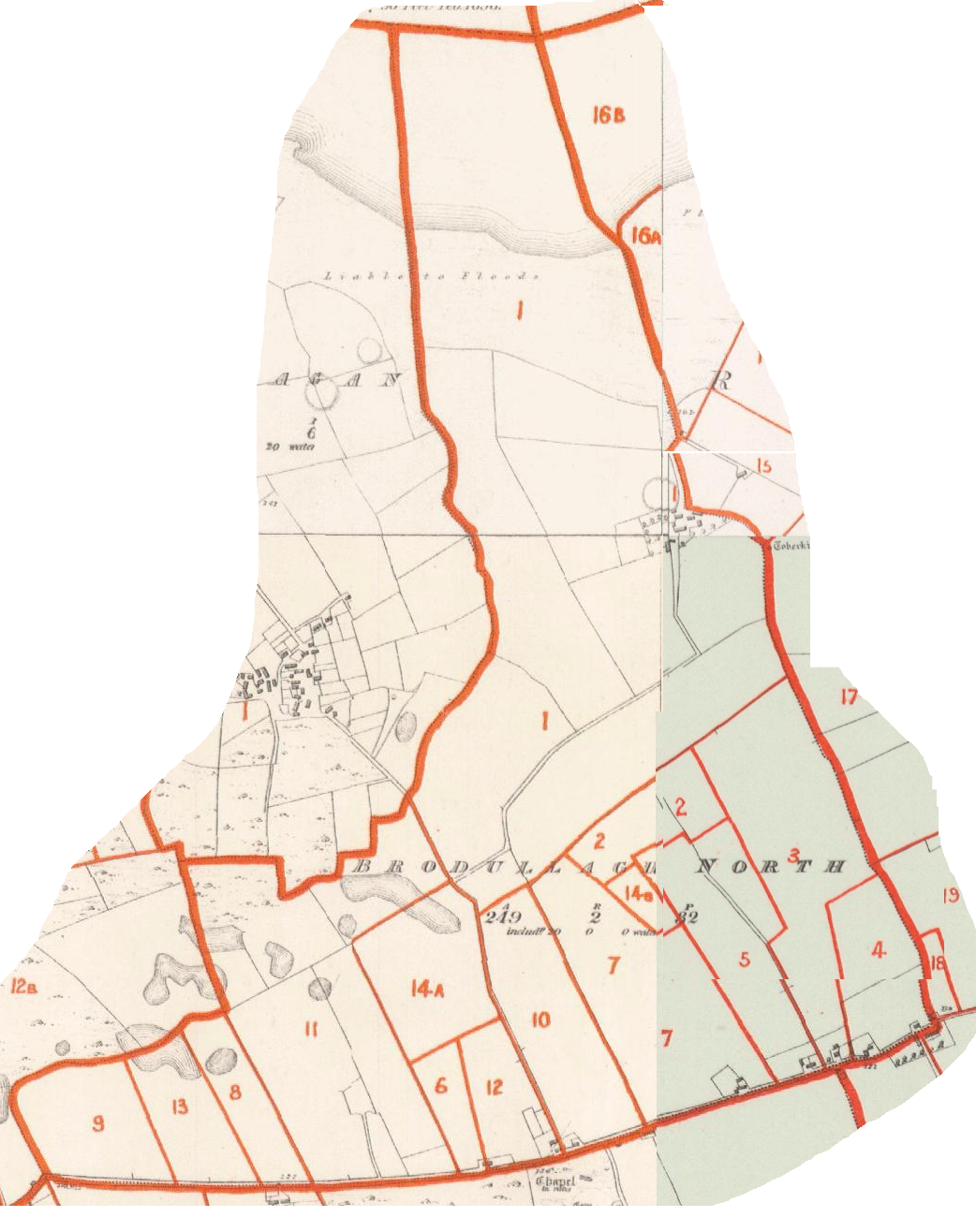 |
Townland plot mapGriffith’s final published valuation of South Mayo is dated circa 1854 due to the fact that Lady De Clifford is listed as owner of Dalgan and Patrick Kirwan owned it until sold in 1853 on account of the Encumbered Estates Act.The original surveys of Shrule were carried out in late 1838 ( from surveyors letters ). Click on the map on the left to see a larger version |
| Tenants Name in the valuation | Landlords name | Comments |
| Denis Beggins | George S. Lynch | |
| Patrick Gibson | George S. Lynch | |
| William Hessian | George S. Lynch | |
| William Keane | George S. Lynch | |
| Malachi Madden | George S. Lynch | |
| Patrick Madden | George S. Lynch | |
| James Moghan | George S. Lynch | |
| Patrick Moghan | George S. Lynch | |
| Redmond Murphy | George S. Lynch | |
| Peter Nolan | George S. Lynch | |
| Matthew Walsh | George S. Lynch |
Tithe Applotments :: 1828 – 38
| Tenants Name in the records | Placename as recorded | Notes |
| Francis D’Arcy | Brodolough | |
| James McGrath | Brodolough | |
| John Walsh | Brodolough | |
| James Sweeny | Brodolough | |
| Hugh Connell | Brodolough | |
| Patrick Madden | Brodolough | |
| Mathias Cohen | Brodolough | |
| Edmond Cane | Brodolough | |
| Bart Lydon | Brodolough | |
| Martin Geraghty | Brodolough | |
| Patrick Laffy | Brodolough | |
| John Naughten | Brodolough | |
| Patrick Fallon | Brodolough | |
| Daniel | Brodolough | |
| Thomas Nolan | Brodolough | |
| John Connor | Botharbee |
Placenames
Placenames mentioned in this townland are :
Field Name Book
Field Name Book description from 1838/1839 noted by the surveyors who produced the O.S maps originally.
Brodologh North
B.S.S.M. : 7
Brodalach. – Meaning uncertain
- Brodullagh Nth : J. 0’Donovan
- Brodelogh : Down Survey Maps
- Brodullagh ( Brodaghlagh ) : Strafford’s Survey
Situated in the N. side of the parish.It is bounded on the
E. by Ramolin td.; S. by the td. of Brodullagh South; W. by Cahernabrock
td.; and on the N. by Mocollagan td.
It contains 249a. 2r. 32p., including 20 acres of water, and
is the property of George Staunton Lynch, Esq., of Clydagh . It is let to
occupying tenants under leases of 21 years, in farms of from 10 to 14 acres,
at a yearly rent of from 18s. to 29s. per Irish acre. The tenants are all
Catholics. The soil is a light sandy . clay, with limestone. There is one
ancient fort in this td.
Brodologh South
B.S.S.M. : 8
See preceding name
- Brodullagh Sth : J. 0’Donovan
A central townland.It is bounded on the N. by the tds. of
Cahernabrock, Brodullagh North, and Ramolin; E, by Ramolin td.; S. by the
tds. of Cloonbanaun and Kinlough; and W. by Carrowoughteragh td.
It contains 502a. 2r. 29p., and is the property of George
Staunton Lynch, Esq., Clydagh. It is let under leases of 21 years, in farms
of from 8 to 50 acres, at a dearly rent of from 18s. to 29s. per acre. The
soil is a light sandy clay. In this td. are the ruins of an old chapel,
and about 1 chain south of the ruins is the site of an old fort with a cave
in it. On the boundary between this and Kinlough td. is a very large fort,
with a cave in it. The tenants on this td. are all Catholics.
The shrule.com placename database covers the Poor Law Unions of Ballinrobe and Tuam roughly a 15 kilometer radius centered on Shrule , the townland database covers most of Connaught in lesser detail .
When searching for a placename type some or all of the word and click search. If you are unsure of the spelling try a part of the word . For example the placename Mocharra sounds like Moharra so if you search for arra you should find it. For example a placename record ( eg Rostaff ) gives the townland ( eg Moyne ) and the civil parish ( eg Shrule ) .
Civil Parish details available :: 40
Abbeyknockmoy , Annaghdown , Athenry , Belclare , Ballinchalla , Ballinrobe , Cargin , Clonbern , Claregalway , Cong (Galway) , Cummer , Dunmore , Donaghpatrick , Kilbennon , Kilconla , Kilmoylan , Kilcoona , Killeany , Killursa , Kilkilvery , Killower , Lackagh , Moylough , Monivea , Killererin , Tuam , Ballinchalla , Ballyovey , Ballinrobe , Ballintober , Cong , Kilcommon , Kilmolara , Kilmainebeg , Kilmainemore , Moorgagagh , Mayo , Robeen , Shrule , Unknown , more to come . . . .Barony details available
Clare , Kilmaine , more to come . . . .Poor Law Unions details available
Tuam , Ballinrobe , more to come . . . .Land divisions and Administration
Go to the Map Resources page for descriptions and explanations of the land divisions used in genealogy plus explanations of terms etc…
Civil Parish Maps
There are two general index maps of the Civil Parishes , one for South Mayo and the other for North Galway . These correspond roughly to the Baronies of Kilmaine (Co Mayo ) and Clare (Co Galway) and show the civil parish boundaries and parish locations in relation to each other.
Townland Index maps .
Official O.S. townland names in Shrule parish
Unknown , Ballisnahyny , Ballycurrin Demesne , Ballynalty , Brackloon , Brodullagh North , Brodullagh South , Bunnafollistran , Cahernabrock , Cloghmoyne , Cloonbanaun , Commons , Cullagh , Dalgan Demesne , Glasvally , Gortatober , Gortbrack , Kinlough , Mocollagan , Mocorha , Mounthenry , Moyne , Ramolin , Rooaunalaghta , Shrule , Shrule Town , Toorard , Cornehan , if the place you seek is not here it’s not an official townland name , search or select the parish link to see all placenames in that parish.
There are townland index maps for Shrule and the surrounding civil parishes available below . They show the townland boundaries and main features of the Civil Parish . They can be useful in locating adjacent townlands or parishes to the one you may be researching.
Categories: .
Content supplied from many sources. eMail me if errors are found.